Building a Mountain of Support
Local lore suggests Mt. Tamalpais’ crowned silhouette resembles a “sleeping maiden,” but this symbol of Marin County is far from asleep. It is a global biodiversity hotspot and a vital natural refuge; awake and alive with wildlife, flora, and a community of scientists and stewards.
Mt. Tam has more than 39,000 acres of habitat divided into four jurisdictions managed by four separate agencies (the National Park Service, California State Parks, Marin Municipal Water District, and Marin County Parks). In 2014, the One Tam partnership was founded to combine the expertise and resources of those agencies with a nonprofit partner, the Golden Gate National Parks Conservancy.
“[One Tam] has been impressive as a collaboration, they stepped in with both feet,” says Marin County Supervisor Katie Rice.
Together, the One Tam partners have detected and controlled invasive plants across vast landscapes, mapped rare and sensitive plant communities, tracked changes in rare plant populations using GIS technology, researched protection of key species amid climate change, released a report on the overall health of the mountain, and monitored indicator species and wildlife across terrains (including using motion-activated cameras to study wildlife around Mt. Tam).
It’s all in an effort to get a comprehensive, big-picture view of the mountain’s resources, to allow managers to prioritize efforts and allocate resources in new ways.
Marin County Supervisor Katie Rice talks about the importance of One Tam. Video
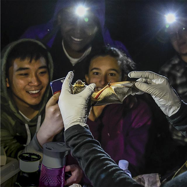
One Tam’s work incorporates community science, which includes sharing knowledge from partner staff and creating opportunities for the public to participate in the research process as part of citizen science efforts. The Marin Wildlife Picture Index Project (WPI) is one such cross-agency public program that peers into the lives of Mt. Tam’s hard-to-study, wild residents. Started in 2015, the WPI is a composite measurement of trends in mammal biodiversity on the mountain.
“Think of [an index] as a delicious burrito of all these measurements that make sense as a whole,” said Lisette Arellano, Community Science Program Manager at One Tam. “I've also heard my Marin County Parks colleague Lisa Michl describe the WPI as a Yelp review for the health of wildlife on Mt. Tam."
In 2018, after three years of cataloging approximately 4 million wildlife images fueled by more than 600 volunteers, the One Tam partners fully cataloged the first three years of photo collection for the WPI project, culminating in the project’s baseline of wildlife occupancy data. This baseline will help land managers learn about the presence of wildlife, compare points in time, location, and species, and better understand how wildlife uses the diverse habitats on Mt. Tam.
“Big-picture community science at One Tam is evolving to be a more sophisticated and well-rounded program, both in terms of the science we’re doing and the quality of the public programs we offer,” said Arellano.
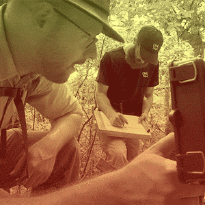
Taking pilot projects to the landscape-scale—or mountain-sized scale in this case—has become One Tam’s forte. Rachel Kesel, Conservation Management Specialist at One Tam, and her team adapted one such pilot from an agency partner into a vast-scale project: Studying serpentine barren habitat (the craggy outcroppings scattered on Mt. Tam, especially on its West Peak). Started in 2016, Kesel and her team look at rare annual plant species on a rare habitat type.
“The first year we started out on Marin Municipal Water District land, got an idea of how difficult it is to access these sites, how to prioritize them, and what the counting is like. Then we took that understanding out to other partner lands who have the serpentine barren habitat type,” said Kesel.
In 2018, as a hallmark of the first four years in partnership, One Tam released “Generating, Scaling Up, and Sustaining Partnership Impact: One Tam’s First Four Years” as a resource for land managers.
Kesel and her team of three conservation scientists reached another milestone: After four years, they, with the help of partner agency teams, completed a primary inventory of invasive plants along the entire road and trail network within their area of focus in Marin County (approximately 435 miles).
In 2015, to increase collaboration between all five partner agencies as well as inform the science-focused public, One Tam began using the Calfora, a public database of California’s plants. Calflora enables the One Tam team to reduce data fragmentation between the different servers of the partner agencies and creates a centralized hub that everyone can access, including members of the public like you. The dataset allows collaborators to make more informed decisions about where to dedicate resources, such as prioritizing restoration sites, monitoring and controlling invasive plants, and more.
Kesel even traveled across the state to lead trainings and collaboration efforts with California State Parks, including trainings in Orange County and the Colorado Desert. She shares One Tam's model of using the Calflora database for the early detection of invasive plants through multi-day trainings for California State Parks' staff, volunteers, and partners.
As One Tam continues to analyze its successes and share its knowledge with communities across the Bay Area and the state, the horizon glows with potential.
In 2019, the mountain’s flora and fauna have a menu of upcoming milestones thanks to Arellano and Kesel. Arellano, along with a new program assistant, will continue the WPI volunteer program, organize BioBlitz opportunities to learn more about the plants, animals, and fungi of Mt. Tam, and pilot new projects and collaborations.
Kesel will continue to lead workshops for California State Parks, collaborate with California Department of Fish and Wildlife on data management options for rare and endangered plant data, and survey the mountain’s waterway corridors and grasslands.
No matter what, both Kesel and Arellano share the hope that One Tam and its science-minded community are able to discover different aspects of the mountain, whether it’s plants or animals, and use their findings to ensure Mt. Tam’s future health.